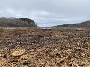
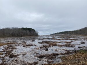
WELLFLEET — The Cape Cod National Seashore, in partnership with Ducks Unlimited and the National Park Foundation, has begun removing 25 acres of mostly live woody vegetation from around the High Toss Road causeway as part of the Herring River Restoration Project.

This work will involve mulching trees and other vegetation, which should “make for a quicker transition back to the salt marsh that it used to be,” said Bri Benvenuti, a regional biologist with Ducks Unlimited.
The restoration is a $70-million ecological project funded primarily by federal and state grants and overseen by a council with members from the National Park Service and the town. The project aims to restore the saltwater and brackish marsh ecosystem that existed here before 1909, when a dike was built across the river’s mouth as it enters Wellfleet Harbor.
As saltwater flow diminished and the water level dropped after the dike’s construction, native saltmarsh vegetation died off and was replaced by freshwater marsh and forest. Without the removal of the vegetation, the return of salt water to the estuary would turn it into a “ghost forest,” Benvenuti said, like the one that appeared at Duck Harbor following a 2021 saltwater inundation.
Removing the vegetation at this stage promotes saltmarsh development, she said. Otherwise, the saltwater-stricken trees take a long time to fall down, and when they do the grasses have a really hard time growing on top of them, she said. Mulching the trees creates a layer of biomass that decomposes much more quickly. “The plants then grow either right up through it or right on top of it,” Benvenuti said.
After mulching began near Duck Harbor following the washout, this recovery was observed with the saltmarsh grass Spartina patens, or saltmarsh hay, flourishing at the site less than a year after the “ghost forest” was mulched, as the Independent has reported.

Faun Koplovsky, owner of Land and Mowing Solutions, who did the earlier mulching at Duck Harbor, is undertaking the vegetation removal here, too. He was given approval to begin work on March 1. All work must be done before April 15, since that date aligns with when the endangered Northern long-eared bat returns from its wintering grounds.
While the vegetation removal and the restoration will destroy some of what’s now freshwater habitat, Benvenuti said, that’s a type of habitat that’s common on the Cape.
Salt marshes, meanwhile, are rarer, she said, and have been degraded by modern human activity across the U.S., including on Cape Cod. “We’re trying to restore it back to what it once was,” she said.
Elsewhere on the River
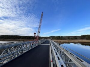
Construction of the temporary bridge at the Chequessett Neck Road dike is nearing completion, according to an announcement from the Friends of Herring River. The temporary bridge will allow workers to begin dismantling the dike across the river’s mouth and installing a permanent bridge with new tide gates.

According to Wes Stinson, the project representative from the engineering firm Environmental Partners, the last major step on the temporary bridge will be for utility companies Verizon and Eversource to “pull their wires” across it. Properties on Griffins Island on the west side of the bridge receive electricity and internet through cables that span the current dike, Stinson said. New connections need to be established before construction on the old dike can begin. Stinson estimated that would happen by the end of March.
After that point, the current dike will be closed to traffic and the one-lane temporary bridge will go into use. For the duration of construction on the permanent bridge, traffic will be able to flow only one way at a time, directed by a stoplight, Stinson said.
Farther upriver, along Pole Dike, Bound Brook Island, Pamet Point, and Old County roads, New England Boring Contractors completed their geotechnical assessments during the week of Feb. 26. They’ll study the composition and compression of the soil around these low-lying roads. This information is important, said Christa Drew, executive director of Friends of Herring River, for later work that will ensure the roads have the structural integrity to support their upgrades when they are raised by as much as six feet as part of the restoration.
The findings will go into the final bid package that Wellfleet is putting together for contractors, Drew said, though she added it’s too early yet to say when that will be released.
Preparations for construction work are also ongoing at the Mill Creek water control structure, Drew said. Mill Creek is a tributary of the Herring River upstream of Chequessett Neck Road. The water control structure is a gate system designed to prevent low-lying properties upstream of the creek from being flooded, according to the National Park Service. The new structure will include five tidal gates that can be completely opened during low tide to allow water to drain out but can be closed at high tide to prevent inundation.
Currently, workers are preparing the staging area where construction equipment will be set up and talking to homeowners in the area about the construction vehicles that should be showing up soon, Drew said.


