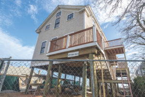
PROVINCETOWN — The Old Reliable Fish House property at 227R Commercial St. may be getting rebuilt on piers, and in the applications there’s an eye-popping number for their height: 17 feet. There’s a house near St. Mary of the Harbor in the East End that now stands nine feet off the ground, and Delft Haven in the West End has approvals to go up three feet.

These varying numbers reflect the complex Federal Emergency Management Agency (FEMA) rules for raising structures, and the costs and other factors that influence property owners’ decisions. Eventually many houses will be raised, but their number is the near future will likely be small.
There are many deterrents in the FEMA standards, said Provincetown Building Commissioner Annie Howard. One is that buildings raised to the standards cannot have basements.
“There can be a crawl space that the floodwaters flow through,” said Howard, “but you can’t have a proper enclosed basement, finished or unfinished. You can store lawn furniture, or kayaks, and if you get a really high raise you can park under it.” But for a lot of homeowners and, especially, business owners, losing a basement is a steep price to pay for an optional fix.
Another deterrent is the high cost of house-raising, and flood insurance isn’t currently expensive enough to provide much incentive. Don DeRocco has been the lead architect for several Provincetown renovations that included raising the structure. Even a lift of a couple of feet can cost $100,000, said DeRocco; higher lifts onto pilings can climb north of $150,000. That’s a lot of money for something that adds no square footage and might subtract your storage space.
Meanwhile, the average policy from the National Flood Insurance Program costs about $2,000 a year in Provincetown, according to Shannon Hulst, a floodplain specialist at the Cape Cod Cooperative Extension. Raising a property vertically out of the floodplain would cut the insurance bill by 90 percent, but still not enough to justify a six-figure house-raising.
But flood insurance rates are set to go up 25 percent a year for second homes and businesses close to the shoreline; other categories of property will see slightly lower increases. Compounded annually, they can add up: a $2,000 insurance bill in 2020 would be a $4,882 in 2024 and $11,919 in 2028. Given eight or 10 years — or one or two big storms — Hulst believes, and people will choose to raise their houses. “Or just pay down their mortgages and not carry insurance,” she said. “But then you’d still have the actual storms to worry about.”

Who’s Going Up?
Most people who are raising their houses now have to, according to Howard. “If you’re doing substantial improvements, worth more than 50 percent of the building’s value, then you’re required to raise the house,” she said. “And if it’s completely new construction and it’s in a flood zone, then it has to be built to FEMA standards.” The requirement kicks in, too, if the building has sustained damage worth more than 50 percent of its value in a storm.
Howard emphasized that the value of the underlying land isn’t relevant — just the assessed or appraised value of the building. “The kind of buildings you find on Commercial Street, especially, are expensive. You can do a lot of work and not hit that 50 percent threshold,” she said. “Most of the projects I see are trying not to hit the threshold.”
The Old Reliable redevelopment is a total teardown, and therefore triggers the FEMA rules, said Howard. The new buildings would be 17 feet above sea level. High tide is around five feet above sea level; the ground at the Old Reliable site averages 8.5 feet above sea level.
A “17-foot raise” is commonly used to describe what’s happening at the Old Reliable, because that’s how FEMA sees it. For an observer standing next to it, with 8.5 feet (of the 17) underfoot, the lower beams of the new building would be 8.5 feet above the ground — still high, but a very different feel from 17 feet. It’s just enough headspace to be able to park cars under the building, said Jeffry Burchard, the lead architect for the project.
It’s easy not to notice, but Commercial Street is full of gentle ups and downs, like a kiddie roller coaster. Bradford Street, its wilder twin, has more dramatic hills and some surprisingly deep valleys. This became especially obvious in the Jan. 4, 2018, storm, which pushed seawater over the Ryder Street Beach and down Gosnold Street in a torrent onto Bradford. The seawater formed a huge pool, soaking Bas Relief Park and damaging dozens of homes and businesses.
FEMA floodplain maps foretell scenarios of powerful wind-driven waves along the waterfront; sloping areas where water runs but does not pool; and inland areas where seawater can collect.
In these inland areas, FEMA rules require houses to go up only a few feet above ground level, although they still have to surrender their basements. That loss, and the cost, would be onerous for property owners, but the changes wouldn’t be all that visible to passersby.
For raises under four feet, “there are a lot of things you can do with the look of it,” said DeRocco. “You can have a wooden wall with flood vents, or vertical cedar boards that break away in a flood. Once you put landscaping in, it all kind of disappears.”
Some properties intersect FEMA’s so-called velocity zone, meaning areas where the physical force of waves is a factor. Those areas have higher flood heights to begin with, and they require an additional two feet of vertical height, which is measured to the lowest beam under the building, not to interior floor level, as in the other zones. The height difference between the “lowest horizontal beam” and the actual front door can be another foot and a half, said Howard.
Buildings in the velocity zone that have sustained damage or are renovated for more than 50 percent of their value can require a noticeably high raise.
A Look at the Future
By comparing the latest U.S. Geological Survey elevation information, found in the online National Map Advanced Viewer, to the current floodplain maps found at FEMA’s online Flood Map Service Center, it’s possible to get a look at where buildings could be rising more dramatically.
A strip of waterfront properties from the post office to Pepe’s Wharf are all about eight or nine feet above sea level. They are almost all in a 13-foot FEMA zone; some are in a velocity zone that adds two more feet. Land’s End Marine Supply, for instance, would have to go up six or seven feet if it crossed the 50-percent renovation threshold.
From St. Mary of the Harbor to the Surfside Hotel is another area of low elevation. Properties are eight to 10 feet above sea level, but the flood zone is 15 feet above sea level, and there’s a velocity add-on. If Surfside were to raise its waterside building to FEMA standards, it would need to be about eight feet off the ground, and its front door would be almost 10 feet off the ground.
Three different stretches of the West End on Commercial Street are low-lying: one around the Coast Guard station and Captain Jack’s Wharf, one near the entrance to Point Street, and one near the Delft Haven cottages. Delft Haven was able to go up only three feet because its renovation didn’t cost enough to trip the 50-percent threshold, even with flood damage from 2018. If it had, the cottages would be going up six or seven feet.
Still Time to Plan
“The thing about these raised buildings is they really don’t have to be ugly underneath,” said Burchard. “You could think of it as a new covered outdoor space. Give it bright ceilings and lighting, and then anything temporary and moveable, whether a farmer’s market or some kind of pop-up, or maybe even café tables, would be OK. You would need a certain amount of headspace — seven feet wouldn’t do. You’d need nine.
“The challenge from a design perspective will be to keep the connection between the pedestrian life on Commercial Street and the interiors,” Burchard continued. “How do people move easily between those levels and build on that vibrant street life that is a way of life in Provincetown?”
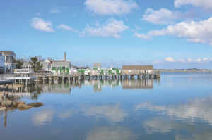
There were a hundred piers in Provincetown harbor 120 years ago, and much of the life of the town happened out over the water. Fifty years from now there will probably be 100 buildings on pilings again. The effect might not be that different — Provincetown could be going back to its past of being built over water.
“I speak from firsthand experience: I live on a precarious old wharf that is magical, and I wouldn’t trade it for anything,” said DeRocco, who lives at Captain Jack’s. “Things will look a little bit more like they used to — except Commercial Street will be higher.”
“We have a chance now to think about this as a community and create our own aesthetics, before everyone has to do this,” said Hulst. “Because we aren’t really there yet.”


