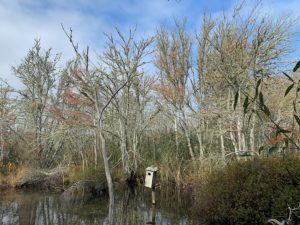
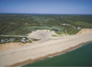
TRURO — George Mooney couldn’t recognize his farm on South Pamet Road. His pasture and vegetable gardens were completely submerged under two feet of salt water during three consecutive nor’easters in March 2018.

Instead of draining out of the river with the outgoing tide, the ocean water that had poured over the Ballston Beach dunes at the valley’s eastern edge stayed on the Mooney farm, and in the entire valley of the Pamet, for two weeks.
The only way out for the salt water was to the west, through a narrow, damaged culvert under Truro Center Road — a culvert built in 1869 to block the flow of salt water from the Pamet Marsh and keep the water of the Upper Pamet fresh.
After that 2018 flood, Mooney couldn’t plant anything for two years. The river water lost its clarity. Invasive phragmites returned and trees began to die. Frogs and turtles disappeared.
“All of my land, even on the other side of the road, was completely submerged for two weeks after those storms,” Mooney said. “It just sat there and killed everything.”
Storm surges that breach Ballston Beach have become a regular event, causing flooding, stagnation, damage, and death.
But in a few years, that could change. The town of Truro is currently in the early stages of a daunting task: restoring the tidal flow to the Upper Pamet River and returning the river to its natural saltwater state.
“We have made a commitment to do the restoration of the Pamet,” said Truro Conservation Agent Emily Beebe.
Restoration Partners
Truro has partnered since March with the U.S. Dept. of Agriculture, Cape Cod Conservation District, and the Woods Hole Group to review all of the scientific data collected on the Upper Pamet by the Army Corps of Engineers, Cape Cod National Seashore, Center for Coastal Studies, and others, since the 1980s. Once their final report is complete — expected in December or January — the town will offer a plan for a new culvert under Truro Center Road.

Then begins a long process of permitting through multiple regulatory agencies, funding, and bidding out to potential contractors. According to DPW Director Jarrod Cabral, the best-case timeline is at least two years.
That is, if the culvert doesn’t fail first.
The fiercest nor’easters usually come between September and April. A March 2020 letter from the Woods Hole Group warned of damage that may occur in the next major storm.
“The town is concerned that this archaic, poorly built culvert structure will fail during the next large storm,” the letter said, “causing severe upstream flooding and either severely damaging or destroying [Truro Center Road].”
Truro has been unable to make headway on the problem while awaiting results of an Army Corps study commissioned in 2016 to analyze the effects of restored tidal flow to the river and private properties along it, said Beebe.
Now the Army Corps report is done, but the scientific review and at least two years of regulatory obstacles remain. So, Truro is preparing itself for an emergency fix in case of a damaging storm.
“If [the culvert] fails before the planning is done, then ideally we have enough information to put something in there that doesn’t have to be temporary,” Beebe said.
Paying for Past Mistakes
Fixing the mistakes of the past has proved to be a challenge.
“Things were done that we are paying the price for now, because the consequences of those projects really weren’t understood until now,” Beebe said. “A tidally restricted water body is an unhealthy water body, period.”
When the Upper Pamet River was initially diked in 1869, the problems were not immediately clear. Private homes in the valley enjoyed access to fresh water. But when a massive storm surge on Oct. 31, 1991, broke through the Ballston dunes and flooded the river, residents and officials realized the culvert could not handle large floods. The freshwater environment would also not survive increasingly frequent saltwater intrusions.
During the early ’90s, local, state, and federal officials pushed for a study to analyze the potential impacts of renewed tidal flow, including possible saltwater intrusion in groundwater and private wells and septic systems.
Then, in 1998, the Army Corps concluded the groundwater would not be significantly affected. Still, the project of returning the river to its natural state did not lift off.
This has been true for other Cape Cod saltwater estuaries as well. Over time, the number of stakeholders grows and governmental regulations pile up. So, the project remains on the shelf. Even if everything runs smoothly, restoration projects can take decades.
The Herring River Restoration Project, for example, was first conceived around 1989. Thirty years later, it is still in the final stages of planning.
“It is a really complicated project involving numerous federal, state, and regulatory agencies, and, quite frankly, it’s a real burden on a small town staff,” said former Truro Selectman Jay Coburn.
Mitigating Flood Risk
Scientists have spent the past two decades analyzing water levels, stream flow rates, groundwater systems, wells, and salinity levels to determine the effects of a return of salt water in the Pamet Valley.

“The information that has been gathered seems to be consistent — that the geology protects the freshwater lens in that area,” Beebe said.
There is also consensus that returning the Upper Pamet to its natural state will mitigate flood risks for Truro’s town center and the private properties in the valley. With less restrictive culverts and free flowing water, an overwash will be able to naturally drain out with the tides. And, according to John Portnoy, a retired National Seashore ecologist recognized for his work on the Herring River Project, an overwash will return to being a natural and important process.
“When you drain salt-marsh peat, it shrinks like a drying-out sponge,” explained Portnoy. “If tidal flow is restored, these overwashes will be healthy, because they will bring in huge swaths of sandy sediments that spread across the marsh surface with the tides, bringing the marsh levels closer to equilibrium with mean sea levels and mitigating flood risks.”
Now, under the leadership of Beebe and Cabral, Truro may have its best shot at restoring the Upper Pamet River and many other waterways, including Eagle Creek, East Harbor, Mill Pond, and the Little Pamet River — all currently in the works. All but East Harbor are backwaters connected to the Pamet Marsh that have suffered significant ecological damage from restricted flow.
“Prior to 2016, I can say with confidence all of those projects were kind of sitting on a shelf,” Cabral said. “We have to pick up the ball and start running as fast as we can.”
For the Upper Pamet River, complete restoration is a distant goal. Even after replacement of the town-owned culvert under Truro Center Road, the town will have to get the state Dept. of Transportation to fix the culvert that runs under Route 6, which also considerably restricts water flow.
Still, the commitment to restore the river is a major step for an environmental project that has failed to lift off for decades.
Editor’s note: An earlier version of this article erroneously identified one of the partners in the Pamet research as the Woods Hole Oceanographic Institution. In fact, it is the Woods Hole Group, an engineering firm.


