WELLFLEET — After two decades of planning, the official review of the massive Herring River Restoration Project will begin on March 9 when the Cape Cod Commission considers the first permits for phase one of the work. This meeting, starting at 5 p.m. at the Wellfleet Council on Aging, is the first of what’s predicted to be two years of hearings before the first shovel hits the mudflats.
Full restoration of the 570 acres of estuary involved in phase one will take 20 more years.
What will the restored Herring River look like? To answer that question, the Independent went on a driving tour last week with Cape Cod National Seashore ecologist Tim Smith and other restoration experts. They pointed out five places where the landscape will be transformed from stagnant lowlands to tidal marsh: the Herring River Dike on Chequessett Neck, the marsh beside Duck Harbor, High Toss Road, Old County Road from High Toss Road to Truro, and the view from Route 6 near Black Pond Road.
Herring River Dike
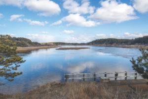
This dike, built in 1909 along with culverts to drain wetlands for mosquito control, caused the river’s degradation in the first place. The first task in restoration will be to replace the culverts with nine gates spanning the new 165-foot bridge. The road will be replaced with a temporary road during construction, and the new bridge will include observation decks and a ramp for canoes and kayaks, said Martha Craig, executive director of the Friends of Herring River.
The greatest transformation will be on the inland side of the dike, now flanked by invasive phragmites on both sides. As tidal flow increases gradually by careful control of tide gates, salinity will go up, killing the phragmites. Smith said Seashore staff are considering removing the phragmites before there is a huge die-off to prevent clogging the water with debris.
In a couple of years, low tide will include exposed mudflats on the land side, Smith said. The culverts now don’t allow proper flushing. So the first change observers will notice is a distinct low tide. The phragmites will be replaced by marsh grass.
This grass has a root system that builds the height of the mudflats to correspond with changing sea level. Birds that like to feast in the mudflats will become frequent flyers here, said Geoff Sanders, chief of natural resource management and science for the Seashore. And the herring, which once put Wellfleet on the map with huge, lucrative landings, will have a much easier time making it to their freshwater spawning grounds, Craig said.

Duck Harbor
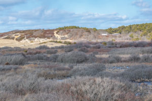
If you go to Duck Harbor to enjoy the sunset, you’ll notice a marsh behind the beach. This is currently a freshwater marsh, Smith said. But a few years after the restoration begins, it will be inundated with salt water. The low-lying areas leading to Duck Harbor are now a strange landscape of wild cherry, scrub oak, and pine, plants that don’t thrive in wetlands but have gained a toehold in the 100 years since the dike was built.
“We have oak and cherry trees growing at sea level,” Smith said. “That’s why it looks so funky.”

High Toss Road
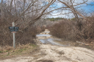
High Toss, a dirt road by the Wellfleet DPW sandpit, will be radically changed by river restoration. In a few years, the road will end at Snake Creek Road, a.k.a. Way 672, and 1,000 feet of High Toss will be scraped down to the elevation of the marsh, so that the water can flow over it.
There are a few homes along Snake Creek Road, two of which were purchased by the Seashore because the rising tide will cause their properties to flood.
Old County Road
Now there is an alarming landscape of dead trees running along Old County Road, a.k.a. Pole Dike Road, from High Toss Road to the Truro town line. This is a huge swath of wild cherry that spread during the driest times of the 20th century and have now died, possibly due to rising water levels, Smith said.
“This is a major plant community,” Smith said.
Shrubby thickets of low-growing green briar, cherry, locust, and red maple will be killed by salt water about 5 to 10 years after the new bridge is constructed. Gradually, marsh grass and water will fill in where there are now acres of half dead trees, Smith said.
In all, about 200 acres of woody vegetation will be inundated by the restoration. Seashore staff are considering removing the trees before the salt water flows, Smith said.
Phase one ends at a small creek at a sharp bend in Old County Road. This is a dike where tidal flow has been restricted for more than a century and where it will continue to be blocked by a new tidal gate, Craig said. Known as Upper Pole Dike Creek, it winds back into Wellfleet Center and eventually to Route 6 by Moby Dick’s Restaurant. This part of Welllfeet will stay as is during phase one, Craig said.
But not so for 15,000 feet of roadway from Pole Dike to Truro. That will be lifted so it does not flood, Smith said. The road will go up by two to five feet, depending on current elevation, Craig said. It will create a barrier against tidal flow into Upper Pole Dike Creek. Moving beyond phase one won’t happen without further permitting, Craig said.
Other Views
It’s hard to imagine a robust Herring River along Route 6, but after the restoration, the views peeking out by Sunnyside Farm Rd. will become less woodsy, more open, and wet. This change, Smith said, will take about 10 years.
And though it wouldn’t be visible on a driving tour, Chequessett Yacht & Country Club’s golf course will also be transformed by the Herring River Restoration — some of the low-lying holes will be raised. The new design and negotiations between the Seashore and the golf course are still ongoing, Craig said.


