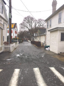
PROVINCETOWN — The Jan. 4, 2018, nor’easter brought a storm surge with it that seemed to lift water out of Provincetown harbor and pour it down Gosnold Street like a river.
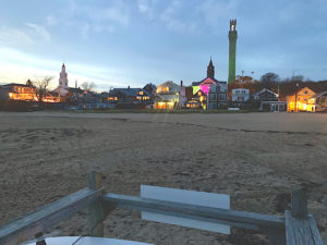
Salt water rose up over the beach and flowed along Gosnold to Bradford Street, where it formed a deep pool around the Bas Relief that flooded scores of homes and businesses. Since then, the town has been working on a dune installation project for a small stretch of beach that would protect the center of town from seawater. The project will need another year to be completed, however, so the smaller, temporary berm that the dept. of public works installed last winter should return this season.

Provincetown’s conservation agent, Tim Famulare, has been heading up the effort to get the dune built, and he updated the Independent on the project’s status.
“Last time we talked, we were looking for nine signatures from nine underlying property owners,” Famulare said. “It’s gotten more interesting since then.”
Shifting sands have made property rights somewhat unclear, Famulare said. The beach has grown dramatically since property lines were drawn in the 1800s, and the historical mean high-water line actually runs through the back of several current buildings. The current mean high-water line is about 40 yards out, because of all the beach that has accumulated since the property lines were drawn. There are competing or overlapping claims to that accumulated beach.
“Current property owners have rights all the way out to the current mean high-water line,” said Famulare. “In most of Massachusetts, property owners actually have some rights all the way out to the current mean low-water line, meaning all of the flats that are exposed at low tide. Provincetown is different, though. Because we were the Province Lands, and all the land west of Howland Street was at one point held in common for the whole commonwealth, that means all of the intertidal flats west of Howland Street are what’s called ‘commonwealth tide lands.’
“There aren’t a lot of commonwealth tide lands in the state,” Famulare went on. “The town has lots of privileges on commonwealth tide lands, and those are defined by the historic mean high-water line, not the current one. That means the property owners have some rights all the way out to current high tide, and the town has some rights all the way up to historic high tide. The whole beach that you can see at Gosnold and Ryder is this area of overlapping rights.”
Over the summer, the town was seeking written permission from the nine property owners to build a seven-foot dune on the beach. Three of the owners gave permission, three have not responded, and two have declined or asked for changes to the project, said Famulare. The ninth property owner is actually the town itself.

“That part is more complex, too,” Famulare said. “We’ve been advised that the granting agencies, the ones who are going to help pay for this project, will be expecting the town to get easements allowing access to the dune and rights to conduct maintenance on it. It can’t just be a one-time permission — it has to be a legal easement. They want to know that if they pay for the project, it will be properly maintained.”
An easement involves property usage rights or restrictions. “You can actually take an easement by eminent domain, without taking the underlying land,” he said. “Constitutionally, the town is obligated to pay the land owner the value of that taking. What’s the value of dune maintenance privileges? We would have to have an assessment of that. Also, we’re allowed to weigh the taking of access privileges against the benefit to the land owner of flood prevention. So there’s that.”
Any eminent domain action would need to be voted on at town meeting. The Gosnold Street dune is a relatively small project, focused on just one flood path that has devastated dozens of properties. Blocking that flood path is of such obvious importance that, even with the tangle of rights, Famulare is hoping to have the seven-foot dune project approved, funded, and built by next fall.
In the meantime, this winter will likely see the resurrection of the two-to-four-foot-high berm that was built by the DPW with existing sand on the beach.
“It started last winter around four feet high, but with the strong winds, it was down to about two feet by spring,” said DPW Director Rich Waldo. “I’m meeting with Tim and Eric [Sussman, Provincetown’s emergency management coordinator] on Wednesday to discuss putting the berm back for this winter.”


