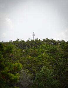
PROVINCETOWN — Nine crews of firefighters from stations as far as an hour away from Provincetown answered the call to put out what was at first considered a “major brush fire” in Beech Forest on Aug. 2, according to Provincetown Deputy Fire Chief Othaine Rance.

The fire ended up burning only three-tenths of an acre, according to National Seashore Public Information Officer Linzy French, and was extinguished less than two hours after the initial dispatch. But the experience raised concerns about the Outer Cape’s wildfire response readiness.
“It was windy,” said Rance. Initially, reports described the fire as covering 100 by 20 feet, he said, but when they got there, it was 100 by 100 feet. “We didn’t want it to get out of hand — best to bring the resources here and turn them around rather than to wait.”
Rance said that he could not recall a significant Provincetown brush fire in the last 10 years.
“This could be a canary in the coal mine,” said Chet Schifone, a former firefighter with 10 years experience with the California Dept. of Forestry and Fire Protection who now lives in Orleans.
“I think there’s been some complacency over the years because it’s a fire-deprived area, which only means that there’s more fuel built up and less experienced people to fight them,” said Schifone.
He outlined several factors that he said make the area from Provincetown to Wellfleet “extremely vulnerable” to wildfires: the region’s remoteness, the abundance of underbrush, and the disrepair of fire roads in the National Seashore.
“Provincetown is Lahaina, Cape Cod,” he said, referring to the coastal community in Maui, Hawaii that suffered a devastating wildfire in 2023. It’s “a fishing town on the water, wooden structures all packed tightly together in an isolated area,” said Schifone. “If something happens, how are we going to get people out in a hurry?”
Fighting the Fire
The Provincetown Fire Dept. responded to a 911 call at 5:42 p.m. in less than five minutes with an eight-person team. There were already three other ambulance calls in progress, so they immediately requested “mutual aid,” assistance from neighboring fire stations, specifically for brush fire units, according to Deputy Chief Rance.
The firefighters set to work with backpack pumps and hand tools, which they used to dig containment lines to keep the flames from spreading. But this failed to extinguish the fire. Eventually, firefighters laid a 1,600-foot hose to pump water from the Beech Forest parking lot up to the dunes 500 feet from the trail where the fire was burning, according to French.
Rance estimated that 30 firefighters from Truro, Wellfleet, Eastham, Orleans, Harwich, Chatham, Dennis, and the Dept. of Conservation and Recreation’s crew from Shawme-Crowell State Forest helped in the effort.
The fire was likely started by human activity, but the exact cause is still undetermined, according to French.
Local and Statewide Risk
Though the Aug. 2 incident did not result in injuries or damage to structures, some Outer Cape residents are growing increasingly anxious about the prospect of a wildfire tearing through the more densely wooded areas of the National Seashore.
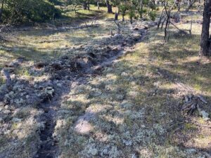
John Marksbury, program chair of Friends of the Truro Meeting House, said that he is worried about “the tremendous buildup of understory debris and the number of dead trees” in Truro and across the National Seashore.
“Friends who live in the Seashore are concerned that the so-called fire roads have not been maintained over the years,” said Marksbury.
“Everything I saw out there was a mess,” Schifone said after going around the fire roads and the old National Park access roads off Route 6. “I wouldn’t want to send a fire engine in there because if the roads are that narrow and that small and brush is growing right up against them, it means the fire is on you.”
According to the 2012 Barnstable County Wildfire Preparedness Plan, 41.2 percent of the county’s land area is considered high risk.
The emergency preparedness director for Barnstable County, William Reilly III, confirmed that the 2012 plan is still the most current version but that the Cape Cod Cooperative Extension was “working on an update right now.”
While Massachusetts is not known for chronic wildfires like parts of the western U.S., state officials urged homeowners in June to take precautions against the threat of wildfires after a historic fire season last year.
“A year’s worth of acreage burned in a few weeks,” said Mass. Dept. of Fire Services Public Information Officer Jake Wark, who called the number of wildfires across the state last fall “unprecedented.” Reports of wildfires went up 1,200 percent last October and November when the state experienced a drought, according to the Mass. Bureau of Forest Fire Control and Forestry.
Over 50 percent of homes in Massachusetts are within a wildland-urban interface zone, according to the Mass. Dept. of Fire Services. That means “there are relatively few places where a significant outdoor fire won’t put people and property in danger,” said Wark.
More Burning Needed
Prescribed burns, or fires set on purpose during low-wind days to clear underbrush and other fuel, can greatly reduce the risk of wildfires, according to Eastham’s David Crary, the former fire management officer at the Cape Cod National Seashore.
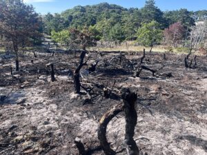
“I always suggest that boutique burning happen, meaning many small burns,” said Crary. “Every week of the year — if you have the staff — get at least two acres burned. That’s 100 acres a year. If you do that for 10 years, that’s 1,000 acres — 1,000 acres of reduced fuels.”
In March, the National Seashore conducted its first significant prescribed fire since 2019, successfully burning 14 acres of underbrush on Fort Hill, as the Independent reported.
At that time, Deputy Seashore Supt. Leslie Reynolds told the Independent that the Park was having trouble filling Crary’s job, which it first posted in April 2024, because the cost of living on the Cape was a challenge. Then, a January 2025 federal hiring freeze, since only partially lifted, further destabilized hiring plans across the Park Service, according to the National Parks Conservation Association.
The fire management officer position is no longer a job at the Seashore because fire management is a “zoned” program. French told the Independent that the job is now based at Acadia National Park in Maine, where it is “in the process of being filled.”
“You have a lot of land out there that hasn’t had any fire, no prescribed burns, no natural fire, no mechanical thinning,” said Schifone. “There’s so much work out there that there needs to be some sort of a public-private partnership.”
According to French, the “Cape Cod National Seashore continues to focus heavily on alternative methods other than prescribed fire to manage fuel loads. This includes mowing, cutting, chipping of brush, and removing fuels from areas.”


