WELLFLEET — The state Dept. of Conservation and Recreation (DCR) will not extend the Cape Cod Rail Trail all the way to Route 6, at least not for the next five years.
Paul Jahnige, director of trails and greenways for the DCR, said at a “round table” discussion on June 14 that the plan to extend the bike path to Route 6 by Oriole Lane in Wellfleet “is not in our five-year capital plan at this point.”
Jahnige said DCR officials still think the scuttled plan is the “safest asset for the community.” But that plan is now abandoned following years of opposition from Wellfleet residents who argued that it was unsafe to lead cyclists to a new terminus and parking lot at Route 6. The land that the DCR purchased by Oriole Lane for a bike trail parking lot is now being used only to store equipment for the DCR’s ongoing construction of the Rail Trail from Lecount Hollow Road to the Wellfleet Hollow Campground, he said. That section of the Rail Trail extension is expected to be completed next year. The 25.5-mile bike path, which begins in South Yarmouth, will now end at the campground, formerly Paine’s, on Old King’s Highway.

Wellfleet residents did not express gratitude for the state’s capitulation to their concerns at the June 14 meeting, attended virtually by 43 people. The select board members instead continued their criticism of the next big public project in the area, the reconfiguration of the Route 6 intersection with Main Street. That project, being handled by the state Dept. of Transportation (DOT), aims to make one of the most dangerous intersections in Barnstable County safer.
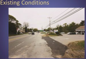
The intersection has over a dozen curb cuts, including at PJ’s restaurant, Cumberland Farms, Bay Sails Marine, a real estate agency, and a gas station. A fast-moving two-lane highway becomes three lanes briefly by the traffic light, which creates a speedway for drivers trying to pass others.
Stantec, the road design company, proposes to get rid of the three-lane highway under the traffic lights and keep just two lanes but add to the southbound side a left-turn lane into the Outer Cape Health Services Pharmacy, said the company’s Jill McLaughlin.
The lack of a turn lane is one reason this intersection has been designated a “high-crash location,” McLaughlin said.
No one had any problems with the changes proposed for car traffic. But many did find cause for worry at changes related to cyclists. The plan is now 25-percent complete, and there will be a public hearing on the design in a few weeks, though no date has been set.

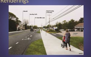
Stantec proposes to add a 10-foot-wide shared pathway for cyclists and walkers on the east side of the highway, with a five-foot bike lane on both sides. The bike lanes would be marked with paint on the asphalt next to the driving lanes. The shared-use walking and biking pathway on the east side, however, would be separated from the highway by a grass berm and paved with white concrete so it’s visible to motorists as a place for pedestrians and cyclists.
Select board member Ryan Curley said a bike path with no physical separation from motorists is not safe. He asked if the shared-use path could become a bike path. Select board members Helen Miranda Wilson and Mike DeVasto, the chair, expressed similar concerns.
Greg Mischel, the DOT project manager, said the shared-use pathway is intended for recreational cyclists who want to get ice cream or access some of the other businesses on the highway. The bike lane on the roadway is intended for serious cyclists, who are speeding through, such as Mischel himself.
“I’m an avid cyclist,” Mischel said. “I don’t use the rail trails; they aren’t safe for me to ride on. Too many conflicts. As a cyclist, I’d prefer to go on Route 6.”
Curley said the bike paths would be much less dangerous if physical barriers such as those used to separate the lanes on the two-lane portion of the highway from Dennis to Orleans, known as “suicide alley,” could be used.
The state officials raised a number of objections to that idea. McLaughlin said barriers could impede visibility for motorists and inconvenience snow plowers.
DeVasto said he’s not sure if a safe solution exists for bicycles, unless alternative routes through Wellfleet that avoid this intersection can be found. But identifying such routes has been elusive, despite years of trying by the Wellfleet Bike and Walkways Committee. Cape Cod National Seashore Supt. Brian Carlstrom is not rolling out the welcome mat to create new bike paths through the Seashore.
“We are not interested in developing new bike paths,” Carlstrom said. “We’re not intending to create new assets we’ll be forced to maintain.”
Jahnige of the DCR said, “The current condition on Route 6 is the least safe.”
His view was echoed by Steven Tupper, the transportation program manager for the Cape Cod Commission, who said finalizing design details is a difficult task. But, he added, people will seek out ways to get to their destination, even without safe options. Tupper asked officials to consider if they “want to encourage people to make choices that aren’t safe.”


