PROVINCETOWN — Some of Cape Cod’s charming roads have so many twists and turns that it’s easy to imagine the horses and buggies that once traveled them. Old King’s Highway from Orleans to Bourne is one such road — officially Mass. Route 6A, it has been protected by a multi-town historic district since 1987.
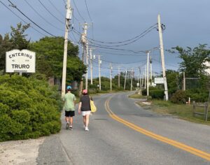
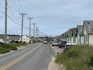
Another stretch of old road is the part of Route 6A that begins in North Truro as Shore Road, enters Provincetown as Commercial Street, runs through Provincetown’s historic district as Bradford Street, and then takes a right turn to become Province Lands Road before reaching the Atlantic Ocean at Herring Cove Beach.
Although beautiful, neither of these roads offers safe space at their margins for pedestrians or bicycles. The driving lanes are narrow, usually there is no shoulder, and sidewalks are very rare. Pedestrians often walk in the roadway, especially in North Truro and the East End of Provincetown, simply because there is no other place to walk.
The Cape Cod Commission is working on a multi-year plan to change that, in part by surveying the public about safety improvements they would like to see. In a meeting at Provincetown Town Hall on June 16, residents of Provincetown and Truro heard from planners at the commission and offered their thoughts on how best to change — or not change — the roadway.
“The first year of this study is to solicit feedback, so we’re doing a lot of public outreach this summer,” said the commission’s senior transportation planner, David Nolan. “The second year, we’ll be diving into alternatives and trying to identify potential improvements.” The goal is to make recommendations to the owners of the roadways, Nolan said.
The state Dept. of Transportation owns most of Old King’s Highway, including the parts in Orleans, Brewster, and Dennis, while the town of Truro owns all 4.6 miles of Shore Road, Nolan said.
In Provincetown, it’s a patchwork. The state owns a stretch from the Truro town line to the junction of Commercial and Bradford streets, plus Bradford Street to its junction at Allerton Street, for a total of 1.15 miles. The rest of Bradford Street and Bradford Street Extension, a total of 2.3 miles, is owned by Provincetown, and the last nine-tenths of a mile of Route 6A — part of Province Lands Road — is owned by the National Park Service.
“The main focus of this study is the state-owned portions of Route 6A, but that doesn’t mean we don’t want feedback on the town-owned portions,” Nolan said.
“If there’s more assistance needed, whether it’s a road safety audit or traffic counts, we’re glad to help,” said the commission’s Colleen Medeiros.
Beautiful but Dangerous
The presentation focused on the ways that Truro and Provincetown’s part of Route 6A are both beautiful and unsafe.
Only two fatal crashes have happened on Route 6A in the last five years, Nolan said — a motorcycle accident in Bourne in 2020 near the Sagamore Bridge and a crash on Bradford Street near Bangs Street that killed a pedestrian in May 2021.
There are numerous “high injury networks,” or places where more minor accidents are relatively common, including Bradford Street at Conwell Street, Nolan said.
A survey taken where Route 6A crosses from Truro to Provincetown counted 2,944 cars and trucks per day last July. There are no recent counts of pedestrians and bicycles in that area, Nolan said — but a count in July 2017 at Route 6 just south of its junction with Route 6A showed 274 cyclists and 32 pedestrians braved that high-speed intersection. The commission plans to collect fresh data at the intersection of Shore and Highland roads this summer, Nolan said.
Several people said that Shore Road and the east end of Commercial Street feel dangerous — especially because many people walk and bike home along those roads in the dark uniforms common at bars and restaurants.
“A lot of workers live in that area and bike home late at night,” said Provincetown Community Development Director Tim Famulare. “I feel very unsafe biking there — I was driven off the road once and wound up going over my handlebars.”
“We need sidewalks really badly,” said Susan Dangle, who lives in the East End. “Instead of walking to nearby beaches, I’m driving so the dog doesn’t get hit. Otherwise you’re forced into sand and ticks and poison ivy. I would do anything for a sidewalk so my grandchildren could take a walk.”

Stephanie Vevers of Bradford Street said that roadway improvements could have unintended consequences.
“A lot of people are concerned about the ‘Hampton-ization’ of Provincetown — why change the current landscape, which is wonderful, historic, and self-regulating?” she asked. “As soon as you put in a better road and better sidewalks, we’re going to end up possibly creating a high-end strip mall, which is not what we want.” She questioned how many cyclists use Route 6A other than during bicycle races.
Bike lanes can be “sort of controversial, especially on historic, scenic roadways,” said Nolan. “We talked a lot about bikes in the Barnstable meeting the other night — a lot of people for bikes, a lot of people anti-bikes.”
Smaller improvements like flashing signs “can go a long way” toward improving safety without changing the character of the roadway, Nolan added.
The commission has created a public comment portal that includes crash reports and other kinds of information, including how wide the publicly owned right-of-way is along each stretch of 6A.
On Shore Road, for instance, the town-owned right-of-way is 50 feet wide, even though the actual road is less than 25 feet wide. On Bradford Street east of Shank Painter Road, the town-owned right-of-way is 35 feet wide, while on Bradford Street Extension — which has sidewalks for most of its length — the right-of-way is only 30 feet wide.
“We want hundreds of comments by the end of the summer,” Nolan said, “and then we’ll package up these ideas and give them to the community.”