PROVINCETOWN — The Route 6 right-of-way, a long corridor that belongs to the town, could someday hold two housing developments and up to 110 parking spaces, according to two recent presentations by municipal consultants.

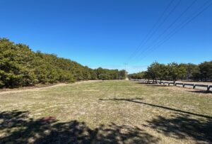
Scott Turner of Environmental Partners told the select board at its March 11 meeting that there were two developable tracts within the town-owned roadbed: one west of the intersection of Route 6 and Shank Painter Road, between the Pilgrim Bark Park and Patrick Patrick’s proposed “Barracks” dormitory project, and another just north of the intersection of Route 6 and Howland Street.
Both tracts would have to be surveyed and separated into parcels The western tract has about 1.4 acres of developable land, and the eastern tract has about 3 acres, according to Turner’s report.
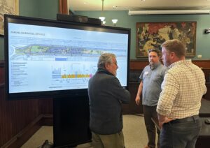
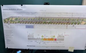
A team of presenters from SLR Consulting then held a public forum on March 18 to display several options for reconfiguring the highway between Shank Painter Road and Conwell Street to add 60 parking spaces and a “multi-use path” for cyclists and pedestrians.
The consultants had been tasked with replacing the 60 spaces at the town-owned lot near MacMillan Pier that will be lost to the construction of the Stellwagen Bank National Marine Sanctuary Visitor Center. They found room in the right-of-way for 110 parking spaces, but their detailed renditions focused on plans for just 60.
All their plans involved a “road diet” that would narrow parts of the highway that currently have two lanes of travel in the same direction down to one lane. The consultants proposed removing lanes from the section that connects Shank Painter Road and Conwell Street. Another “road diet” is already planned for the part of Route 6 that runs from Shank Painter Road west to Herring Cove.
What’s Buildable
The Environmental Partners study was funded by town meeting voters in April 2022 as Article 20, which called for a consultant to assess the wetlands, habitat rules, and engineering restrictions in the Route 6 right-of-way.

There are several large “bump-outs” where the right-of-way expands beyond its standard width, all of which are close to intersections. One of them, which encompasses about 3 acres just west of Conwell Street, has too many wetlands and buffer areas to be developable, the report concluded.
The study determined that the 4-acre area west of Shank Painter Road, which includes the Pilgrim Bark Park and two small wetlands, has 1.4 developable acres, while the 3-acre site north of Howland Street is almost entirely developable, with only a small part of its northern edge falling within a 50-foot wetlands buffer.
Community Development Director Tim Famulare said it’s hard to know what the state Dept. of Transportation had in mind when these areas were included in the right-of-way. “They might have thought they needed a cloverleaf or some other complex intersection, or even space for an equipment depot,” he said.
Two of the sites were later used for leaching fields for the town’s wastewater treatment plant: the area under the dog park and a half-acre just north of Howland Street.
Those leaching fields can all be moved to Motta Field as part of the town’s $75-million sewer program that was approved at fall town meeting in 2022, Famulare said, which means the Howland Street site would be free of infrastructure for the first time in decades.
That area is included in the state’s priority habitat for rare and endangered species. Almost the entire region north of Route 6 is priority habitat, according to the state’s maps, and until a remapping in 2017 so was much of the town’s West End, Famulare said.
“The state doesn’t tell you what species are found where, because they don’t want people trying to relocate or destroy endangered species,” Famulare said. “Typically, they will put in certain construction controls or limit work to certain times — but I’ve never seen a project have to change its footprint.”
A rough analysis of the developable areas indicated that about 50 units could be built at the Shank Painter site and between 100 and 150 units at the Howland Street site, Famulare said. “That would be for a larger, more dense development than the 3 Jerome Smith project,” he said.
Select board members were happy to learn about the Shank Painter site but less sure about the Howland Street site. “I imagine the conversation will be very different between these two parcels,” said board member Leslie Sandberg.
“I cringe at the thought of development on the other side of Route 6,” said John Golden.
“I just never thought we owned it,” said Sandberg. “I thought it was all National Seashore.”
Road Diets and Parking Spots
On March 18, the town’s consultants presented three concepts for the redesign of the highway between Shank Painter Road and Conwell Street.

That area is eligible for a “road diet,” said transportation planner David Sullivan, because the federal threshold for a change from two lanes to one is 875 vehicles per hour and that stretch of Route 6 averages 520. “Based on that, by dropping a lane there will not be a massive queuing of vehicles into the Conwell or Shank Painter intersections,” Sullivan said.
All three plans removed a lane from the southern, or Shank Painter-to-Conwell, side of Route 6, while two of the three plans also removed a lane from the northern, or Conwell-to-Shank Painter, side of the highway.
The plans differed primarily in the circulation of vehicles and how the consultants envision people exiting those vehicles. Two options put the parking in the median, forcing people who’ve parked to cross Route 6 to reach town. The third option put the parking spaces along the southernmost edge of the roadway, alongside the multi-use path for pedestrians and cyclists.
The consultants also discussed the town’s transportation and multi-use path survey, which had raised the possibility of replacing the Old Colony Nature Pathway with a paved bicycle trail.
Fifty-five percent of the more than 800 people who responded to the survey were against that plan, and Sullivan said his firm opposed it as well.
“I came up here with one of our wetland scientists and we walked this trail, which is an old railbed,” Sullivan said. “It would be similar in design to bike trails in other Cape Cod towns, but at the end of it, you still have to put your riders back onto Route 6. So, we said no to the Old Colony Nature Trail.”
About 40 people were at the forum, and most of them erupted in applause at that point.
“Thank goodness — now I can go home!” exclaimed someone from a back row.


