PROVINCETOWN — Turning disparate stretches of bike trail into a connected network can be like carpentry: the junctions and joinery require just as much attention as the long boards.
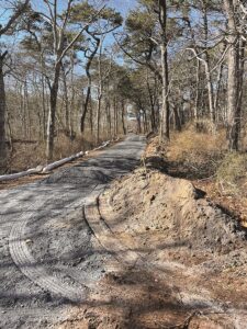
One such piece of joinery is currently under construction in the Cape Cod National Seashore. A pre-existing one-third-mile stretch of bike trail running alongside Race Point Road from just north of Route 6 until it reaches the Beech Forest Trail is being resurfaced and widened and will be open to bicycle traffic by late May, according to National Seashore planner Lauren McKean.

Thick with tree roots, the spur had “just degraded to a point where it’s not really usable,” said Max Cliggott-Perlt, treasurer of the Provincetown Bicycle Committee.
According to bicycle committee chair Rik Ahlberg, the repaved spur is only one part of a broader plan to create a continuous route from MacMillan Pier to the Beech Forest, which runs along Standish Street, Cemetery Street, and Conwell Street using a “not-very-obvious routing.”
“The final piece of this puzzle is adding bike lanes along the town’s portion of Race Point Road,” Ahlberg said. This idea is on the town’s radar and has been discussed at various meetings, but a formal plan has not yet emerged, according to Provincetown Dept. of Public Works Director Jim Vincent.
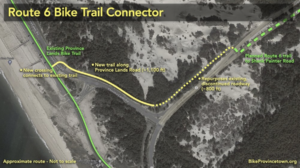
After Labor Day, work will begin on another bike trail project in the Seashore: the new Route 6 Bike Trail Connector, which will follow the easternmost 800 feet of Route 6 and then veer north along Province Lands Road to Herring Cove Beach, where it will meet that section of the Province Lands Bike Trail.
McKean said that the connector project should be finished by early November. Both projects include widening trails to a standard 10 feet, restriping center lines, and improving drainage in low-lying sections.
These short trails fill key gaps in a continuous path for cyclists from Commercial Street to the open Atlantic. Provincetown was recently named America’s “most bikeable small city” in an analysis by PeopleforBikes.
Shank Painter Road Project
The Route 6 connector being built this fall will eventually link up with a longer bicycle and pedestrian trail that will replace the two southern lanes of Route 6 between Shank Painter Road and Herring Cove. That multimodal path is part of the state-and-federal-funded Shank Painter Road Project, which aims to make that street a more vibrant, accessible, and safe gateway to and through town.
According to a design plan by Environmental Partners and submitted to MassDOT in 2019, the project will set aside dedicated space for sidewalks, bike lanes, and new trees, and will install a roundabout at the Route 6 intersection in 2019, applying a “Complete Streets” design along the Shank Painter corridor. The final segment of the plan is a “road diet” for the stretch of Route 6 between Shank Painter Road and Herring Cove that would merge vehicular traffic onto the two northern or Seashore-side lanes and create a shared path for bicycles and pedestrians on the two southern or town-side lanes.
That places the bike trail on the southern side of the newly narrowed Route 6, while the 800-foot connector to Herring Cove will be on the northern side. The town just received a $400,000 Federal Lands Access Program (FLAP) grant to fund a road crossing between the two trails.
“That’s always a tricky part of any type of project: who owns the land?” Vincent said. “Is it the state, the feds, or the town? The [FLAP] grant will help us do the work right at that boundary and take care of some of those complications.” The exact details of the crossing are still being worked out, he said.

The select board saw the design for the Shank Painter Road project nearly four years ago, and conversations about redoing the road began as early as 2016. The construction timeline has now been pushed back from the upcoming fiscal year, which starts in July, to the fiscal year after that.
At the Feb. 10 meeting of the Cape Cod Joint Transportation Committee, state officials said that a final design justification workbook for the project was required before a public design hearing could happen. Jim Fitzgerald, the Environmental Partners consultant on the project, also mentioned the proposed Court Street stormwater pump station project as another reason for the delay.
Vincent agreed that the pump station, added to the Environmental Partners plan for the town in 2021 to mitigate extreme flooding on Court Street, may have prolonged the process. “It does involve all three agencies, and different agencies have different requirements, and it just takes longer to review,” he said.
On March 27, the Cape Cod Metropolitan Planning Organization voted to spread the funding for Shank Painter Road — to the tune of just over $16.3 million — over three years of Transportation Improvement Program ledgers from 2025 to 2027.
The 2019 design, which in industry parlance was a “25-percent design,” will go to a public hearing in Provincetown this June, Vincent confirmed. Usually, a 75-percent design can be expected within six months of the hearing, and a 100-percent design six months later.
Once completed, cyclists will be able to ride designated multi-use paths from Bradford Street to Herring Cove, passing through town, state, and federal land along the way. Seeing the project through is a priority for the bicycle committee, Cliggott-Perlt said. “Two or three years ago, it was off to a good start, and since then it has fizzled a bit,” he noted.
Safety Is Still an Issue
While the Beech Forest spur, Route 6 Connector, and Shank Painter Road project will all help cyclists get from Provincetown to the Province Lands, the bike infrastructure connecting Provincetown to Truro and Wellfleet is a thornier problem. In 2017, the Cape Cod Commission prepared an Outer Cape Bicycle and Pedestrian Master Plan for the National Park Service, which recommended a separated multi-use path along stretches of Route 6 to complete a 10-mile route from the Cape Cod Rail Trail extension in South Wellfleet to Provincetown.
At present, while bikeable back roads abound in Wellfleet and Shore Road provides a relatively safe route for cyclists entering Truro from Provincetown, it is impossible for a commuting cyclist to avoid travel along Route 6 while traversing the entire middle section of Truro. A new state bicycle safety law mandating a “safe passing distance” of four feet or more for motorists went into effect on April 1, though it’s unclear what enforcement of the statute might look like on the Outer Cape.
More detailed plans are now emerging for a Route 6 bike path. At a Truro Bike & Walkways Committee meeting on March 13, state officials and consultants offered two preliminary designs for Project 61540, a 7.8-mile 12-foot-wide path with a planted buffer and stretches of sidewalk that would run along a to-be-determined side of Route 6 from Main Street in Wellfleet to Shore Road in Truro.
“We’re also making more progress on the march towards P’town, if you will,” MassDOT planner Michael Trepanier said. Trepanier told the Truro committee that they were the first stakeholders to see these plans, and that the state had a lot of “municipal coordination to start working through.”


