TRURO — As part of a plan to improve road safety and travel for cyclists and pedestrians, a 4.6-mile stretch of Route 6 — from South Hollow Road to the Provincetown line — could go on a “road diet” in the next few years, Jarrod Cabral, director of the Dept. of Public Works, told the select board on Aug. 12.
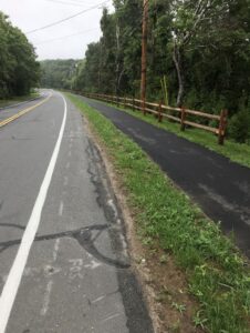
This means that instead of two lanes of traffic in each direction, this stretch would have only one lane going each way. The rest of the roadway could then be converted into an 8-to-12-foot-wide asphalt path, separated from the road with a patch of grass or other barrier, where people could walk or ride bikes.
Road diet ideas first came into view here when they were suggested in a 2017 Outer Cape Bicycle and Pedestrian Master Plan. That 100-plus-page document, the result of collaboration among the Cape Cod Commission, the National Seashore, and the towns of Provincetown, Truro, and Wellfleet, proposed that cyclists need a path between the three towns past the terminus of the Cape Cod Rail Trail in South Wellfleet. It named a shared use path along Route 6 as a possible solution.
Steven Tupper, deputy director of the Cape Cod Commission, which has worked closely with the Outer Cape towns on transportation planning, told the Independent on Aug. 19 that nothing is set in stone, and any idea under consideration will go through a public comment period. That period hasn’t been scheduled yet.
All four Outer Cape towns are undergoing highway improvements. Scheduled road resurfacing is what has put follow-up on the 2017 plan in motion in Truro.
“It’s on the regular schedule for Mass DOT to do a resurfacing, and they’re taking an opportunity to think about what’s the best use of that right-of-way and that existing pavement,” Tupper said. Eighty percent of that resurfacing project, he said, will be paid for with federal funds and 20 percent with state funds.
In his report to the select board, Cabral said he hoped the road diet would improve safety by naturally reducing the speed of traffic. “Speeding is a relatively common traffic offense seen on Route 6, especially since it is the connecting corridor to our neighboring communities,” Truro Police Chief Jamie Calise wrote in an Aug. 20 email.
Cabral told the select board that in a recent meeting with Mass DOT no mention was made of changing the speed limit. Still, a road diet could reduce traffic speeds “naturally,” he said.
Tupper explained that that happens because, first, there’s the predictable effect of making cars travel in a single lane. But there’s also a psychological effect, where the different appearance of the road “dictates how fast people travel,” he said. Seeing that there might be a cyclist on the road and seeing narrower lanes, for example, “that’s how someone decides what a safe speed is for them.”
Slower traffic would make it easier for pedestrians and cyclists to cross Route 6 at troubling intersections such as Stotts Crossing, the short connector between the highway and Shore Road, Cabral told the select board.
Elsewhere on Route 6, Cabral said, DOT and the town will consider adding an island in the middle of the highway to make it easier for pedestrians to cross from the Truro Community Center, which houses the Council on Aging, to Head of the Meadow Road. The DOT and the town will also consider some changes at South Hollow Road, where there is already only one lane of traffic in each direction along with an unprotected bike lane, because that segment is also scheduled to be resurfaced.
Members of the DOT’S design team “did mention they’re looking closely at the school access,” Cabral said. “They want to be able to make that safer.”
Another change to be considered is the removal of one of two highway access points that are close together and which they believe might be redundant: Whitmanville Road or Castle Road, which quickly leads to Whitmanville Road.
“Do you need both access points from Whitmanville onto Route 6?” Cabral asked. “Do you close one of those? If so, which one do you close?”
Removing a lane of traffic — the road diet — will require other changes, Tupper told the Independent, such as, possibly, left turn pockets: “There may be some places where they want to put in a little pocket for left turns if there’s a lot of left turns at a specific location.”
Highway exits are another issue the state will need to look at, Tupper said. When the bike lane goes across an intersection, that will need to be made obvious to motorists.
Route 6 Truro construction is funded in federal fiscal year 2028, said Colleen Medeiros, the Cape Cod Commission’s transportation program manager.
Tupper added that the Federal Highway Trust Fund is a “fairly stable funding source” that is “not subject to the Congressional appropriations cycles.”
Still, the project could face at least one hurdle: according to the Federal Highway Administration, a road diet is less feasible for a road that sees more than 875 vehicles per hour in one direction. In the peak of summer, this North Truro stretch of Route 6 can surpass that upper limit, according to the 2017 report, although for the rest of the year volume is much lower.
“Those are the things that need to be looked at in detail in these next phases,” Tupper said.
Cabral told the select board that the project could begin by fiscal 2027. But that timeline has since been pushed back, according to Tupper. The state now has construction beginning in the spring of 2028. When it does, Truro could become the testing ground for similar changes on other parts of the highway on the Outer Cape.
John Goggin, a spokesperson for Mass. DOT, told the Independent in an email on Aug. 19 that the Truro road diet “will help verify the viability of future lane reductions as part of the Outer Cape Shared Used Path project along Route 6.”